| |

| |
T O U R I
S M M A P S
Tourists
need up-to-date accuracy, detail but not distraction, and reassurance
when they’re in unfamiliar territory.
|
|
|
|
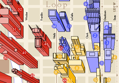 |
The
world-famous shapes of Chicago’s skyscrapers distinguish this map,
given to those taking Chicago Architecture Foundation tours. |
| |
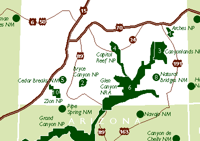 |
The
publisher of a book on America’s National Parks commissioned maps showing
National Park Service sites in each state. |
| |
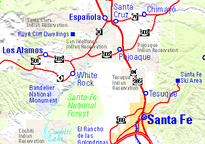 |
A
map included in the Santa Fe, New Mexico, telephone directory shows the
variety of daytrip destinations in Northern New Mexico. |
| |
 |
Chicago’s
North Michigan Avenue is crowded with stores and attractions. Angled labels
make it possible to fit more names in the proper locations, and give this
map a distinctive look for the Greater North Michigan Avenue Association.
|
| |
 |
Visitors
using the AIA Guide to Chicago Architecture have 43 maps to guide them to
such attractions as buildings designed by Frank Lloyd Wright in Oak Park.
|
| |
 |
Concierges
at Chicago’s Hilton hotels give these maps to guests to guide them
to nearby tourist attractions. Downtown Chicago appears on one side, and
a metro area map with CTA rail system inset on the other. |
|
|
 |
This
large display map to guide long distance travelers visiting a Travel Center
beside I-55 in Missouri required stitching together data from six state
highway departments. |
|